What's new

Where in the World

It's Kinzua Bridge/Viaduct in Pennsylvania. It spanned the Kinzua Creek in McKean County. In 2003 it was destroyed by a tornado and now looks like this:

<img src="http://www.ipadforums.net/attachment.php?attachmentid=37018"/>

The picture was taken 2011. (Wikipedia)

If I'm right, I can't post another challenge yet. So someone else may do so.

Absolutely correct. The photo, of course, was from a time prior to when the tornado destroyed the bridge. http://en.wikipedia.org/wiki/Kinzua_Bridge

The next challenge is open to any iPF member at the request of J.A..
 
As no one posted a challlenge, I'll do myself.

My questions:
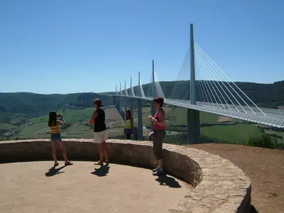
What's the name of this bridge? In which country can you find it? What's it's length and height?
Plus: Which events took place in December 2004 and on May 13, 2007?


image-541453782.webp

(Credits: Wikipedia)
 
Last edited:
As no one posted a challlenge, I'll do myself.

My questions:
What's the name of this bridge? In which country can you find it? What's it's length and height?

<img src="http://www.ipadforums.net/attachment.php?attachmentid=37023"/>

(Credits: Wikipedia)

This is the Millau Bridge in France. It's span is 1.6 miles. It's 1,132 ft maximum height.

It's a pretty new bridge and was completed on budget.

Sent from my iPad using iPF
 
This is the Millau Bridge in France. It's span is 1.6 miles. It's 1,132 ft maximum height.

It's a pretty new bridge and was completed on budget.

Sent from my iPad using iPF

Correct.

Do you also know the event I asked for? I added it two or three minutes after I posted the challenge.
 
Correct.

Do you also know the event I asked for? I added it two or three minutes after I posted the challenge.

OK. The Bridge was dedicated and opened in Dec 2004. Then...
. The bridge was closed to road traffic so that runners could cross it on 13 May 2007. I wish I'd known about that and would have run the 14.7 mile course :)

Sent from my iPad using iPF
 
OK. The Bridge was dedicated and opened in Dec 2004. Then...
. The bridge was closed to road traffic so that runners could cross it on 13 May 2007. I wish I'd known about that and would have run the 14.7 mile course :)

Sent from my iPad using iPF

Correct! :-) It's your turn!
 
Thanks Johanna,


Now, keeping with the "theme". What transport route is this on? Roughly when was it built? What is its name? What river does it cross?

image-2618722621.webp

Sent from my iPad using iPF
 
Thanks Johanna,

Now, keeping with the "theme". What transport route is this on? Roughly when was it built? What is its name? What river does it cross?

<img src="http://www.ipadforums.net/attachment.php?attachmentid=37025"/>

Sent from my iPad using iPF

Google goggles should identify this. It is south of me

Sent from my iPad using iPF
 
As somebody who enjoys the thrill of the hunt, and the learning experience it offers - I urge players to consider the Google / Goggles option as a search method of last resort.

A generic search often leads to specific types of architecture and geography, which helps you narrow the field of potential targets. Cryptic clues including a play on words by the challenge poster, can also move game play along.

My 2 cents for what it's worth and a whole lot more fun than plopping a picture into image matching software.

AA

Sent from my iPhone using iPF
 
Last edited:
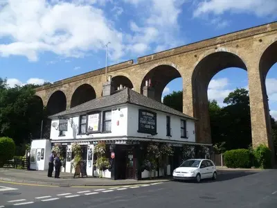
Without using Google / Goggle, and instead using "south of me" being Bromley in Sir Richard's case - I'm going to say the "Horton Kirby Railway Viaduct."

If so - it crosses the River Darent which cuts through the Darent Valley. It spans almost 400 feet over 10 support arches.

The viaduct train crossing was activated in 1858 by the East Kent Railway. It enabled the railway to extend track from Strood to Bromley.

AA

image-1764244778.webp
(Image Credit: GeographDOTorgDOTuk)
 
Last edited:
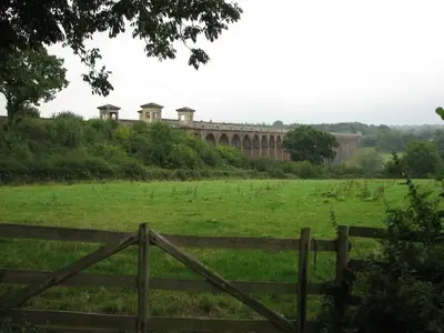
It's the Ouse Valley Viaduct, also known as the Balcombe Viaduct, crosses the River Ouse. It's on the London-Brighton Railway Line, north of Haywards Heath and south of Balcombe. It is 450 m long and 29 m high. It opened in July 1841.

image-2920787294.webpWikipedia
 
It's the Ouse Valley Viaduct, also known as the Balcombe Viaduct, crosses the River Ouse. It's on the London-Brighton Railway Line, north of Haywards Heath and south of Balcombe. It is 450 m long and 29 m high. It opened in July 1841.

<img src="http://www.ipadforums.net/attachment.php?attachmentid=37030"/>Wikipedia

Scifan, you have it. The challenge is yours now :)

Sent from my iPad using iPF
 
I'll be offline for several hours and won't be able to monitor a challenge. Any iPF member who chooses, may post the next challenge.
 
As somebody who enjoys the thrill of the hunt, and the learning experience it offers - I urge players to consider the Google / Goggles option as a search method of last resort.

A generic search often leads to specific types of architecture and geography, which helps you narrow the field of potential targets. Cryptic clues including a play on words by the challenge poster, can also move game play along.

My 2 cents for what it's worth and a whole lot more fun than plopping a picture into image matching software.

AA

Sent from my iPhone using iPF

So I feel silly, I didn't know either existed. I think I'll still not use them, I learn so much from everyone finding these, plus I may know some.
 
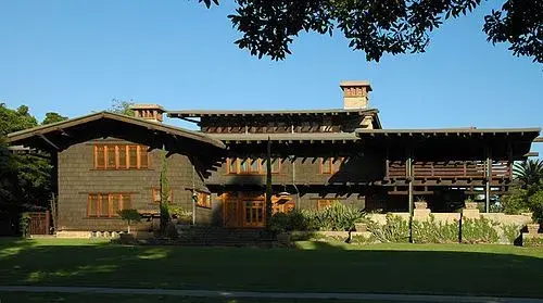
Where would you find this house? What is it's name? What was the original owner famous for?


image-2148843207.webpPhoto Credit: Wikipedia
 

Most reactions

Latest posts

Back
Top