twerppoet iPad Fan Jul 27, 2012 #3,736 Some kind of clear overlay for looking up data in a table, or perhaps keeping track of lines as you enter data into the computer?
Some kind of clear overlay for looking up data in a table, or perhaps keeping track of lines as you enter data into the computer?
AdmiralAdama iPad Fan Jul 27, 2012 #3,737 twerppoet said: Some kind of clear overlay for looking up data in a table, or perhaps keeping track of lines as you enter data into the computer? Click to expand... It's not a clear overlay. It's numeric table, that is geographic in nature. The first and second image are parts of the challenge item. Here's another clue. AA Sent from my iPhone using iPF
twerppoet said: Some kind of clear overlay for looking up data in a table, or perhaps keeping track of lines as you enter data into the computer? Click to expand... It's not a clear overlay. It's numeric table, that is geographic in nature. The first and second image are parts of the challenge item. Here's another clue. AA Sent from my iPhone using iPF
twerppoet iPad Fan Jul 27, 2012 #3,738 An atlas table showing distance between cities? If not, I've no other ideas. I'm also at a loss for what the different colored lines might be for. Edit: I suppose they might be part of the map's key/legend.
An atlas table showing distance between cities? If not, I've no other ideas. I'm also at a loss for what the different colored lines might be for. Edit: I suppose they might be part of the map's key/legend.
AdmiralAdama iPad Fan Jul 27, 2012 #3,739 twerppoet said: An atlas table showing distance between cities? If not, I've no other ideas. I'm also at a loss for what the different colored lines might be for. Edit: I suppose they might be part of the map's key/legend. Click to expand... You've got it. The table shows distance between cities. The other images are symbols for roads. Here's the Atlas they're from. Over to you tp. AA Sent from my iPhone using iPF
twerppoet said: An atlas table showing distance between cities? If not, I've no other ideas. I'm also at a loss for what the different colored lines might be for. Edit: I suppose they might be part of the map's key/legend. Click to expand... You've got it. The table shows distance between cities. The other images are symbols for roads. Here's the Atlas they're from. Over to you tp. AA Sent from my iPhone using iPF
twerppoet iPad Fan Jul 27, 2012 #3,740 Yay for me. Here is an easy one. What would one normally do with this item?
twerppoet iPad Fan Jul 27, 2012 #3,742 Not as easy as I thought, or maybe everybody's concentrating on the Olympics. Zooming out a bit.
twerppoet iPad Fan Jul 27, 2012 #3,744 BostonDan said: Is it a dog treat? Click to expand... That it is. Not my dogs favorite, but she deals with them promptly. The challenge is yours.
BostonDan said: Is it a dog treat? Click to expand... That it is. Not my dogs favorite, but she deals with them promptly. The challenge is yours.
B BostonDan iPF Noob Jul 27, 2012 #3,745 It looked very healthy. ;-) I will post a hint soon, need to keep it quiet as my kids are asleep. Attachments ImageUploadedByTapatalk1343439661.793622.webp 22.5 KB · Views: 99
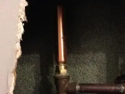
fleur07 iPF Noob Jul 27, 2012 #3,746 Copper piping in a wall, most likely plumbing. If I'm right it's open to anyone!
B BostonDan iPF Noob Jul 27, 2012 #3,747 Im looking for the specific device it is. It is made of copper, but has a specific purpose.
B BostonDan iPF Noob Jul 27, 2012 #3,749 Hopefully this helps, the top of the device is closed and does not connect to anything. The device serves an important purpose.
Hopefully this helps, the top of the device is closed and does not connect to anything. The device serves an important purpose.
twerppoet iPad Fan Jul 27, 2012 #3,750 An accumulator to smooth sudden pressure changes in the water pipes?